GeoData
Back to all posts-

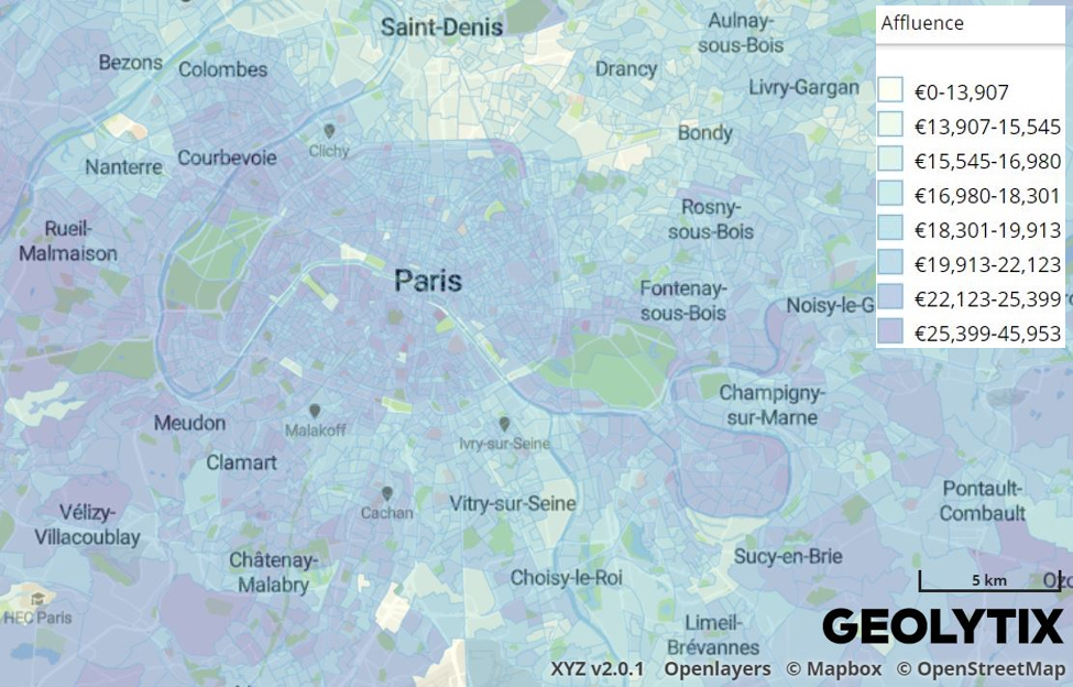
Beyond footfall: where retailers really outperform in London
Card spend data reveals where London retailers actually outperform their own estates. From high-conversion rail hubs to high-productivity retail parks, discover the locations driving real growth.
Published 16th February 2026 • Tags geodata
-

Your Complete Guide to UK Banking Location Data
An overview of the uses of banking location data and how it can support mapping, analysis and planning across a range of projects.
Published 18th November 2025 • Tags open-data, geodata
-

From Footsteps to Forecasts: The Power of Small Area Footfall
Discover how Geolytix footfall data can transform the way you understand your locations and identify where to open next.
Published 30th May 2025 • Tags mobility, geodata
-

Grocery Growth: UK Supermarket and Convenience Openings in 2024
2024 saw major shifts in UK grocery retail with bold expansions, innovative formats, and strategic closures shaping the industry.
Published 31st December 2024 • Tags open-data, geodata
-
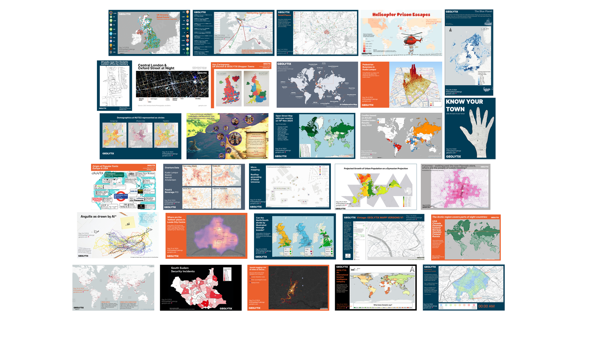
GEOLYTIX and the 30 Day Map Challenge 2024
Daily social mapping project happening every November: https://30daymapchallenge.com/. The third year we have joined this as a team, see all our maps here.
Published 9th December 2024 • Tags geodata, our-team
-

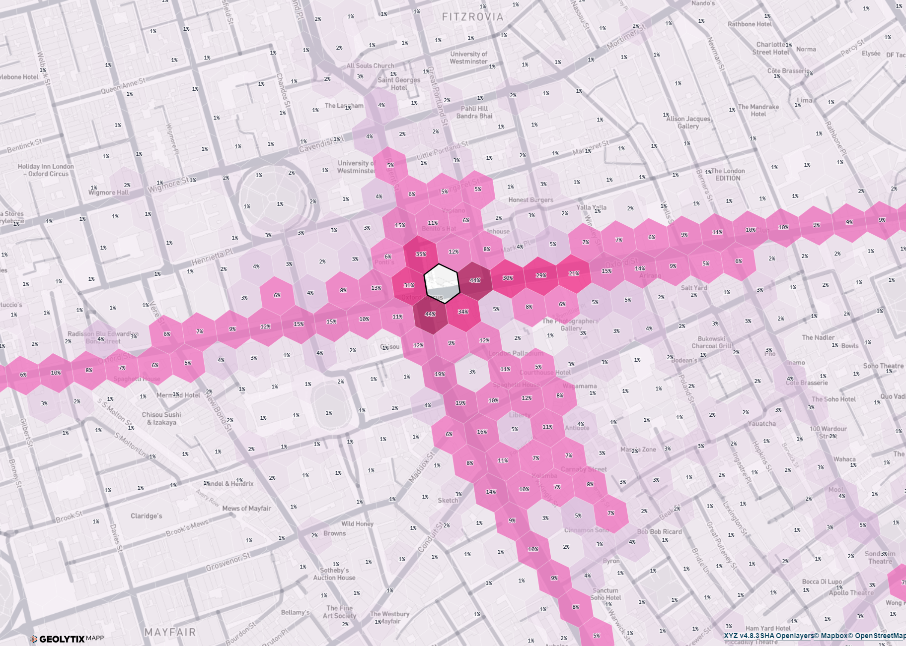
Oxford Street Reinvented
Ben recently took to Oxford Street to ask the question "can it make sense to have 4 stores in the same vicinity, no matter how strong that Retail Place is?"
Published 14th August 2024 • Tags market-visits, geodata
-

Interaction Surfaces explained: Why Context is Everything
Christoph Mülligann, Chief Innovator at Geolytix, takes us behind the curtain of developing Interaction Surfaces and gives us his unique take on making sense of mobile data.
Published 31st May 2024 • Tags geodata, mobility, mapp, ai
-

Interaction Surfaces: How to maximise store density and minimise overlap
If it was possible to maintain 3 successful stores in one area instead of 2, wouldn’t you want to know?
Published 29th May 2024 • Tags geodata, mapp, mobility
-

Interaction Surfaces: Illustrate The Complexity Of The City
Our new MAPP tool, Interaction Surfaces, lets you interrogate complex pedestrian interactions in urban areas and start to see the wood for the trees.
Published 28th May 2024 • Tags geodata, mapp, mobility, ai
-
Interaction Surfaces: Understand common pedestrian movement patterns for better site location
Whether its finding new opportunities or analysing impacts of new store openings (your own or a competitors), GEOLYTIX Interaction Surfaces can help. Find out more.
Published 8th May 2024 • Tags geodata, mobility
-
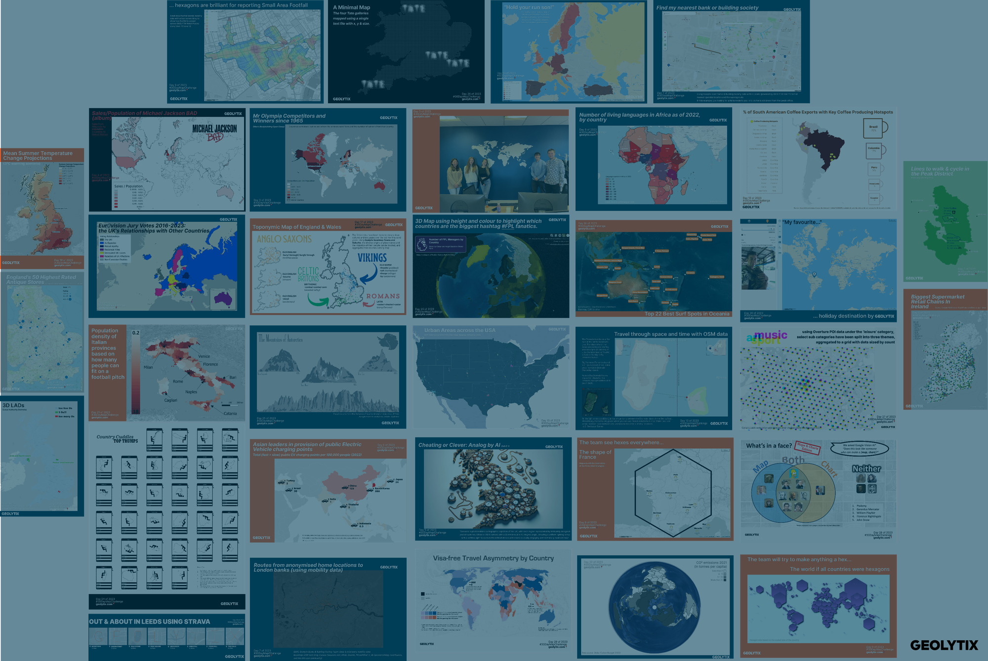
GEOLYTIX and the 30 Day Map Challenge 2023
Daily social mapping project happening every November: https://30daymapchallenge.com/. This is the second year we have joined this as a team, see all our maps here.
Published 1st December 2023 • Tags geodata, our-team
-

International Busyness Index: Identify Activity Hot Spots across the world
Geolytix Busyness Index can be calculated worldwide and makes it easy to spot busyness trends.
Published 11th September 2023 • Tags geodata, mobility
-

Debenhams: Two years (& two months on)
Over two years since the physical presence of Debenhams on our high streets ended, we review 126 units they left vacant. What’s become of them?
Published 2nd August 2023 • Tags market-visits, geodata
-

Geolytix Footfall Tracker: Retail Place Daily Visitor Numbers
Looking to identify high street or shopping centre decline, retail regeneration or seasonal uplifts? Footfall Tracker gives you a robust answer.
Published 26th April 2023 • Tags geodata, mobility
-

The Power of Geolytix Footfall: Daily Footfall Counts for over 15,000 Retail Places
Why do we love using Geolytix Footfall? Remove the guesswork from micro site selection and immediately identify the busiest locations are.
Published 19th April 2023 • Tags mobility, geodata
-

Mobility Data - Behind the Scenes
"Sometimes the hype around a source of data can become so incessant and insistent that we don’t even question what’s underlying the enticing outputs." We go behind the scenes of mobility data.
Published 28th February 2023 • Tags mobility, geodata
-

New towns are not built too often in the UK: Exploring Sherford
The UK is known for its many historic towns but new towns are occasionally built. Sarah explores Sherford which welcomed its first residents in 2017.
Published 17th January 2023 • Tags geodata, market-visits
-

Creating Robust Small Area Population Estimates
The 2021 Census results for England and Wales are gradually being released at small area. How will conducting a census during a pandemic affect the numbers?
Published 8th December 2022 • Tags census, geodata
-
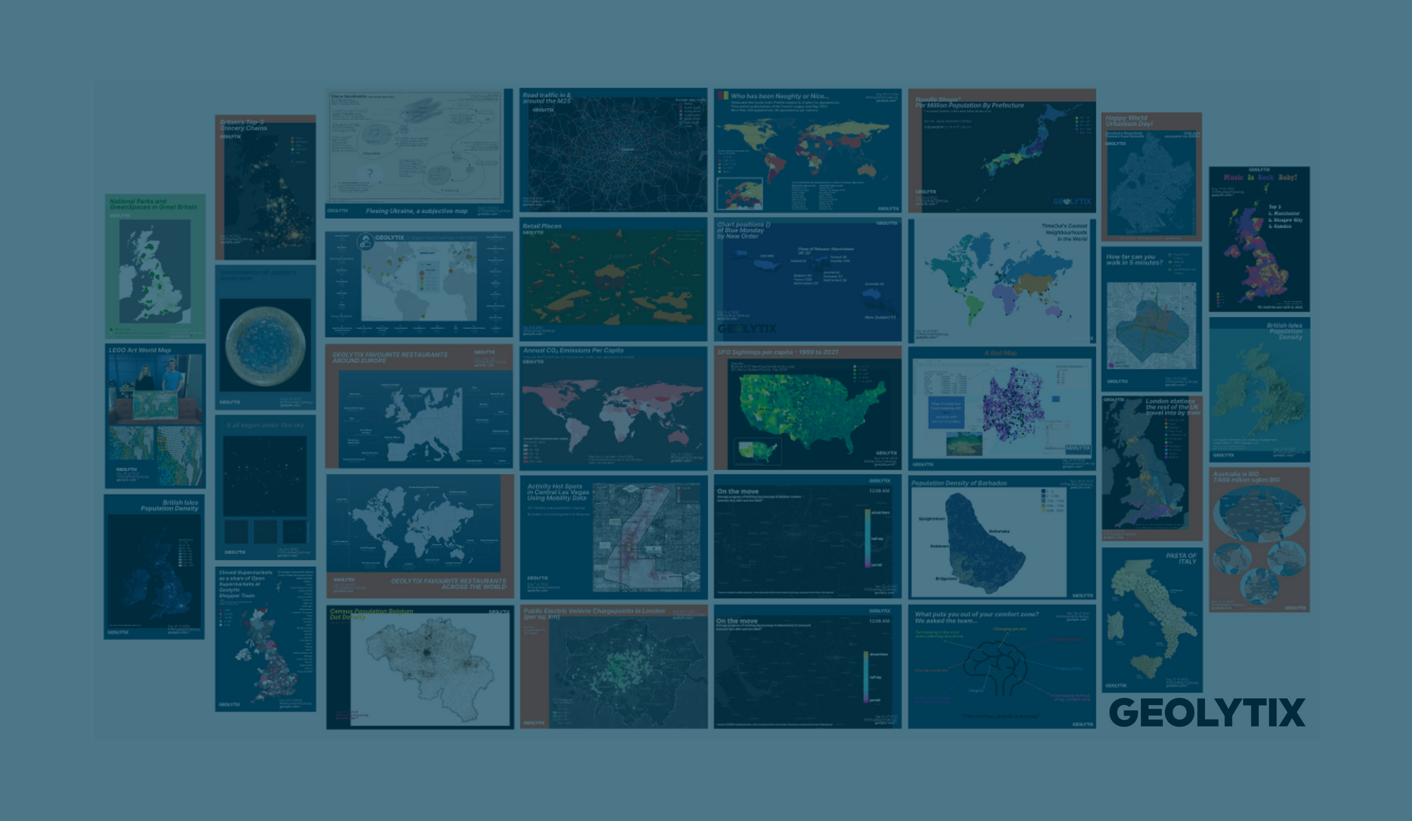
GEOLYTIX and the 30 Day Map Challenge 2022
Daily social mapping project happening every November: https://30daymapchallenge.com/
Published 30th November 2022 • Tags our-team, geodata
-

Poland GeoData for Location Intelligence
Are you a retailer or restaurant? Does Poland feature in your expansion plans? Geolytix has GeoData to support your business.
Published 20th October 2022 • Tags international, geodata
-

10 years of Demographic Change in Poland
With the processing and release of the 2021 Census starting to come through Jacek reviews how the demographics of Poland have changed over the last 10 years.
Published 11th October 2022 • Tags census, geodata, international
-

Geolytix International GeoData
Geolytix GeoData underpins the informed location decisions we support our clients with.
Published 7th October 2022 • Tags geodata, international
-

Geolytix: An International Location Intelligence Company
From start up to scale up, Geolytix has worked with some of the biggest retail, leisure, and restaurant brands in more than 55 countries over the last 10 years.
Published 6th October 2022 • Tags our-team, geodata, mapp, international
-

Bridging the gap between Censuses
The UK Census is conducted every 10 years, so how do we bridge the gap between to get granular population and household estimates and forecasts?
Published 26th August 2022 • Tags geodata, census
-

Filling the gaps with {mydentist}
How Europe’s biggest dental provider uses GEOLYTIX MAPP to manage their network of practices and target the most appropriate opportunities for growth.
Published 24th August 2022 • Tags market-visits, geodata, mapp
-

LondonShuffle
Six years ago we had a team social to a newly opened Shuffleboard club called LondonShuffle. We were delighted to support them recently with some location data and analysis.
Published 27th July 2022 • Tags team-thoughts, geodata, market-visits
-

10 new GeoData packs in 10 countries
Not only are we celebrating 10 years of Geolytix this month we have been busy created new GeoData for 10 countries.
Published 28th October 2021 • Tags geodata
-

From South Korea to the UK : Understanding 'how busy is this road?'
We introduce you to one of our most ambitious data networks we have created - a modelled value count for every major road in the county of operation; we started with South Korea.
Published 28th July 2021 • Tags geodata
-

Has Yorkshire bounced back?
The impact of the opening of outdoor seating on mobility levels in Yorkshire, compared to pre-COVID (2019) and lockdown (January - April 2021).
Published 6th July 2021 • Tags geodata, team-thoughts
-

Office Place Recovery
Through the last 15 months, we have been using mobility data and applying it within 8,000 of our Retail Place boundaries to produce a weekly read on activity levels across the UK.
Published 9th June 2021 • Tags team-thoughts, geodata
-

London has bounced back
The impact of the opening of outdoor seating on mobility levels in London, compared to pre-COVID (2019) and lockdown (January-April 2021)
Published 1st June 2021 • Tags team-thoughts, geodata
-

Modelled Traffic Volumes - a new product in our Road & Network data pack
Our new product in the Road & Network data pack - Modelled Traffic Volumes, answers the question "how busy is this road?"
Published 27th May 2021 • Tags geodata
-

Geolytix open Supermarket Retail Points - 20th Edition
The 20th version of Geolytix’s open data set; Retail Points, has now been released.
Published 10th May 2021 • Tags open-data, geodata
-

Global Retail Places
Retail Places identify areas where potential customers are attracted to interact with a retail environment. Retail Venues sit within these to specifically define a concentration of retail within a retail place.
Published 25th February 2021 • Tags geodata
-

Will the most walked path be the online high-street in 2021?
Covid-19 and lockdowns in particular have affected how the UK is shopping, predominately a surge in online shopping. Once lockdown is lifted, will we be itching to get back to the high-street or will online shopping continue to rise in popularity?
Published 8th February 2021 • Tags geodata, team-thoughts
-

Life After Lockdown
Anecdotally, town and city centres have been busy since England Lockdown 2 ended last Wednesday. We’ve been busy processing up mobility data from Saturday to see what it tells us about the 18,000 Retail Places we monitor.
Published 9th December 2020 • Tags geodata, mobility
-
Did Somebody Say…It’s Beginning to Look a Lot Like Christmas…
Wednesday marked the end of England’s four-week Lockdown II. Many retailers will now be looking to salvage what they can following a tumultuous year. The run-up to Christmas is always a condensed & critical period but in 2020 this is exacerbated. So, what can we expect during these next three weeks?
Published 4th December 2020 • Tags geodata, mobility
-

The Wales Firebreak
The Wales Firebreak that came into effect on 23rd October attracted a great deal of media attention last week, with photographs of cordoned off ‘non-essential’ aisles a regular feature. But has the Wales Firebreak worked in terms of reducing activity?
Published 4th November 2020 • Tags geodata, mobility
-
Consistency Across Borders
As retailers increasingly take a more regional or even global view of multi-channel strategy, the importance of defining and applying a consistent data and analytical approach across borders has also increased.
Published 3rd November 2020 • Tags team-thoughts, geodata
-

Historic England - High Street Heritage Action Zones
How can you use data to identify ‘similar’ locations? For retailers, looking for areas similar to those with high performing stores, this may be a simple enough task. Counts of surrounding population, competition and demographic data lend themselves well to similarity modelling.
Published 21st October 2020 • Tags our-team, team-thoughts, geodata
-
Geolytix Town & Suburb Boundaries
A common remark we get from clients is their surprise that there is no official published source of suburb/town/city boundary. 8 years ago, Geolytix’s created the Town and Suburb data pack.
Published 12th October 2020 • Tags geodata
-

Geolytix Seamless Town & Suburb Boundaries
A common remark we get from clients is their surprise that there is no official published source of suburb/town/city boundary. 8 years ago, the first iteration of Geolytix’s Seamless Town and Suburb were created.
Published 29th September 2020 • Tags geodata
-

How can data help our tourist towns recover?
We’ve been pondering this question at Geolytix. Here in our local state of Victoria, Australia, our tourist towns have been hit by the double whammy of horrific bushfires followed by the Covid-19 Pandemic.
Published 10th August 2020 • Tags geodata, team-thoughts
-
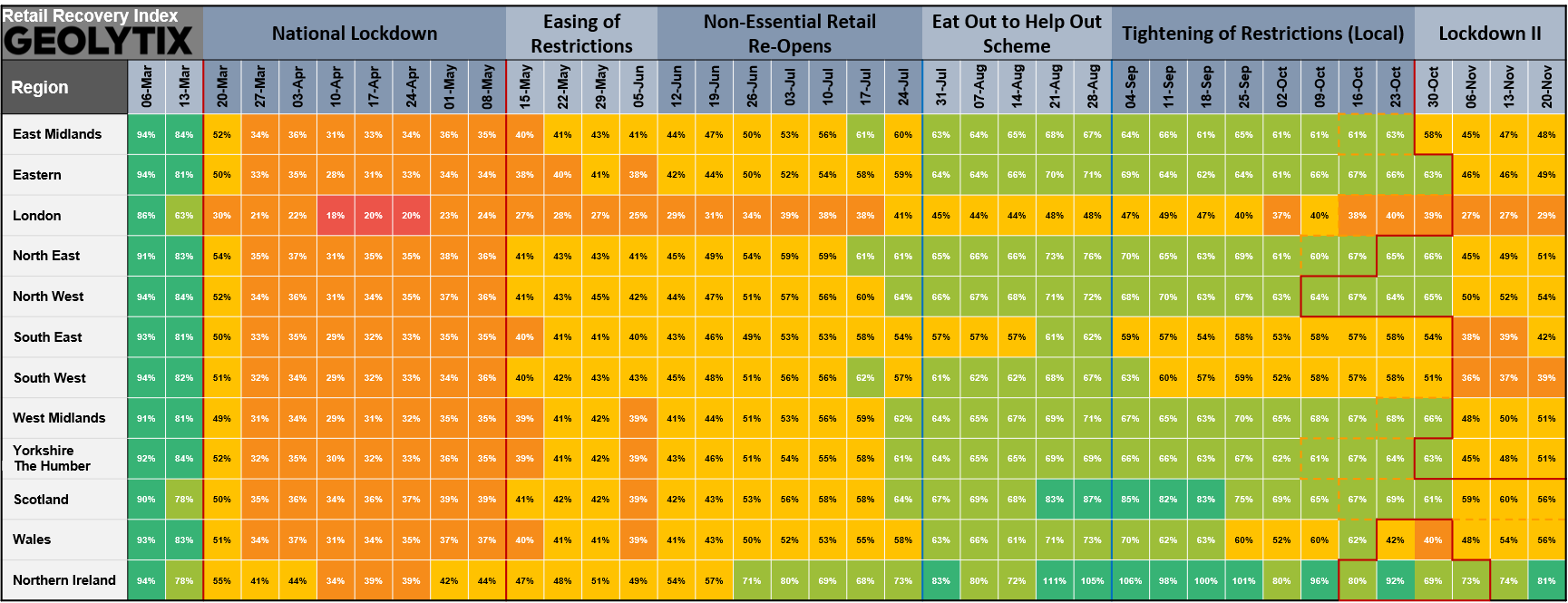
PRESS RELEASE: Geolytix Retail Recovery Index
There seems to be a broad consensus on top-level recovery rates in the UK as lockdown eases. But every city, town, village, shopping centre, retail park and local parade has its own story.
Published 8th July 2020 • Tags mobility, geodata
-

Retail Recovery - Que Sera Sera?
We’re often asked what a good level of forecast accuracy looks like. The answer is always: it depends. Some things are hard to forecast. Really hard. Even harder than convenience store turnover. Like, will things ever return to normal?
Published 29th June 2020 • Tags geodata, mobility
-

Geolytix UK Postal
"For speed and certainty always use a postal district number on your letters and notepaper"
Published 9th June 2020 • Tags geodata
-

Geolytix UK : Retail Place Boundaries
Geolytix Retail Places is the ultimate product for profiling, describing and modelling UK retail. The data set currently has 21,942 identified areas of retail reaching from City Centres to parades of 3 units. It continues to be a popular and established product since it's very first release in 2012.
Published 22nd May 2020 • Tags geodata
-

Geolytix in The House. Helping the Co-op support Wellbeing in the Community
On Tuesday Blair, Dan and Jasmin attended the parliamentary launch of the Co-op Community Wellbeing Index at the House of Commons. Geolytix worked in partnership with the Co-op to develop this index which aims to quantify the wellbeing of communities.
Published 6th March 2020 • Tags our-team, geodata
-

UK Public Transport
Geolytix produce multiple GeoData packs which are updated annually and available as a purchased product or use within our services work. Public Transport is vital data when making location-based decisions.
Published 31st January 2020 • Tags geodata
-
European Census and Indices
Census data is a powerful source of statistics able to describe a population. The data can be complex, messy, expensive, difficult to access and vary from country. Geolytix has taken the time to remove this hassle and make the data accessible, functional and open.
Published 27th January 2020 • Tags census, geodata, open-data
-

Geolytix is Small but Global
I’ve been following Geolytix with interest since it was founded back in 2012.
Published 28th October 2019 • Tags our-team, geodata
-

The Added Value of Banking Data
Across the numerous sectors and markets we support and operate in there is one common theme that keeps arising… and don’t worry it’s not Brexit.
Published 30th September 2019 • Tags geodata, team-thoughts
-
Machine Learning with spatial Big Data: How Uber helped us get there.
Sometimes we look for answers outside our cosy little GIS bubble. In this case we applied well-established information retrieval techniques to truly understand hyperlocal movement patterns in mobility data.
Published 5th August 2019 • Tags geodata, ai
-
Inferring Traffic Counts from Network Centrality
We were recently asked by a client to incorporate an element of traffic and road utilisation into the modelling of their network blueprint as they investigate opportunities to locate drive-thrus.
Published 12th July 2019 • Tags geodata, ai
-

Republic of Ireland Retail Places
Retail Places is one of our most popular datasets. We have now expanding this to Republic of Ireland.
Published 23rd October 2017 • Tags geodata
-

Public Transport Data
Public transport data is fundamental to any consumer-orientated location planning project.
Published 7th September 2017 • Tags geodata
-

Education Data 2017
Currently in the UK, about 25% of the population are in education.
Published 20th June 2017 • Tags geodata
-
Retail Points Update - May 2017
Not only has it been busy in the Geolytix office but as always in the turbulent world of food retail there having been many announcements over the past few months.
Published 31st May 2017 • Tags open-data, geodata
-

GEOLYTIX Point of Interest Data 2017
Location planning spans a wide range of industries from retail to the public sector. Complex decisions require a multitude of inputs, and that is where Geolytix’s Point of Interest (POI) data can be used.
Published 22nd May 2017 • Tags geodata
-

Retail Places – 2015 Update
If you need a product that provides an accurate retail background to support your decision making, this is it.
Published 16th July 2015 • Tags geodata
-

UK Universities
With over 2.2 million students currently studying (and spending) in the UK it pays to know where they are.
Published 21st April 2015 • Tags geodata